Infrastructure and Permafrost Degradation in Point Lay, Alaska
By: Benjamin Jones, University of Alaska Fairbanks (UAF); Jana Peirce, UAF; Billy Connor, UAF; Mikhail Kanevskiy, UAF; Yuri Shur, UAF; Tracie Curry, Northern Social-Environmental Research; Peppi Bolz, UAF; and Bill Tracey, Native Village of Point Lay
The Native Village of Point Lay (Kali) on the North Slope of Alaska has been identified as the second-most permafrost thaw-affected community in the state of Alaska (Denali Commission, 2019). The village has 82 residential units, housing a population of approximately 330. There are several North Slope Borough municipal structures and the Kali School that serve the community. Most of the residential buildings in the village are built on an elevated surface underlain by ice-rich permafrost that is susceptible to thaw and terrain subsidence. Issues associated with thawing permafrost have dramatically increased in the village during the last decade. Water and sewer lines have failed, homes are being affected by ground subsidence (Figure 1), the community's freshwater drinking lake drained because of permafrost degradation in 2016 (Wolken et al. 2021), and one of their water storage tanks ruptured last winter.
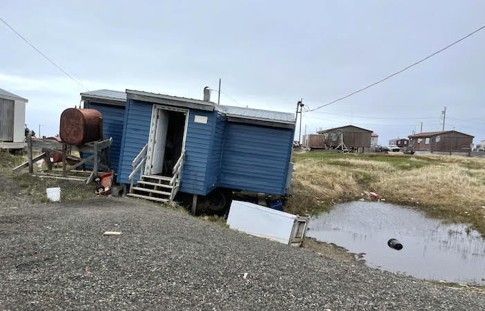
In June 2022, with funding from NSF and the Cold Regions Research and Engineering Laboratory (CRREL), a team of researchers from the Institute of Northern Engineering and the Institute of Arctic Biology at the University of Alaska Fairbanks, as well as Fairbanks-based Northern Social-Environmental Research, traveled to Point Lay to observe, study, and discuss the effects of thawing permafrost on homes and critical infrastructure in the village. During the research visit, we: (1) studied permafrost properties and ground-ice conditions in three main terrain units (elevated areas, slopes, and drained-lake basins); (2) mapped the community with a drone to quantify the effect of thermokarst (the process by which ice-rich permafrost thaw produces characteristic depressions, e.g., pits and troughs) on village infrastructure; (3) conducted visual assessments on the effects of thawing permafrost on piling foundations; and (4) interviewed residents about their observations and experiences of permafrost thaw to better understand the impact of landscape changes as well as local concerns and information needs.
Presence of Extremely Ice-Rich Permafrost
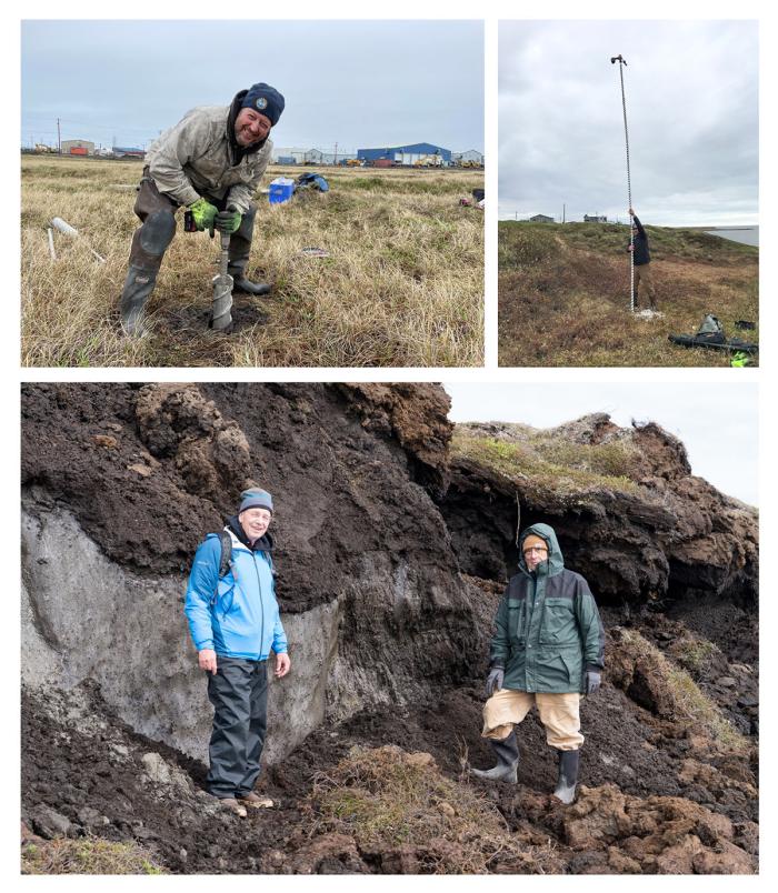
During the studies in Point Lay, ten boreholes up to three meters (m) deep with total depth of 13.6 m were cored to describe and sample frozen soils and ground ice, and 19 boreholes up to 5.5 m deep with total depth of 24.9 m were drilled to estimate depth to wedge ice and vertical extent of ice wedges (Figure 2). Based on our field measurements of excess ground-ice content, we estimate that the thaw subsidence potential of the ice-rich permafrost is nearly 40 percent of its volume in the upper several meters. We also observed that melting of ice wedges caused more than two meters of differential subsidence in and around infrastructure.
Elevated areas and adjacent slopes underlain by Yedoma (ice-rich silt penetrated by large ice wedges) have wedge-ice content that probably exceeds 50 percent by volume, and the vertical extent of ice wedges at the higher elevations may reach ten to twelve meters. Most ice wedges within all terrain units were encountered at depths 0.4–0.8 m below the surface, which makes them vulnerable to thermokarst and thermal erosion.
Drone-Based Detection of Permafrost Thaw Impacts
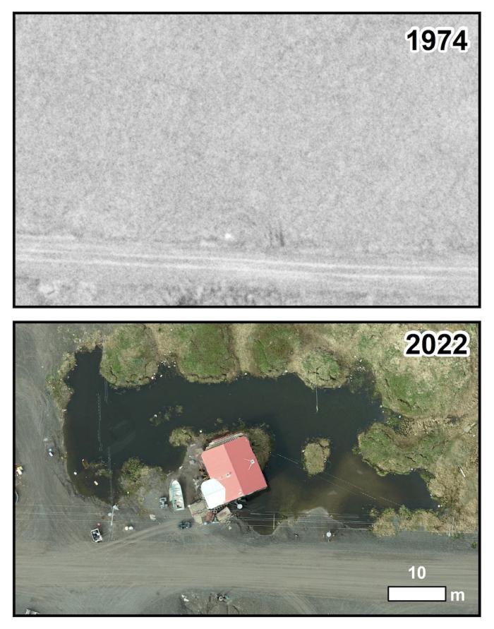
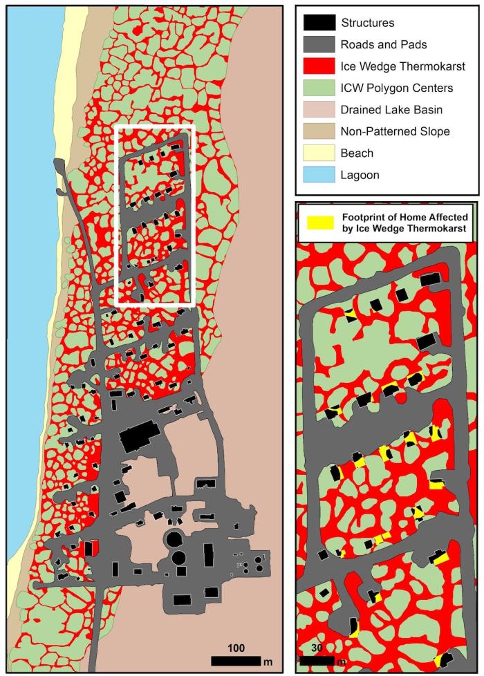
We mapped a 110-hectare (ha; 275 acres) area using a survey-grade drone with a high-resolution digital camera to produce an orthomosaic (high-quality aerial photos of the area that are stitched together) and digital surface model of the village and its surrounding area. The orthomosaic provides visible indicators of thawing permafrost near infrastructure that can be compared to historic aerial photographs (Figure 3), whereas the digital surface model provides very accurate topographic information that we can use to measure permafrost thaw subsidence. Additionally, we processed the digital surface model data using algorithms that remove all infrastructure and interpolate a digital terrain model so that we can identify homes and buildings affected by ice-wedge thermokarst. Initial estimates indicate that thermokarst troughs and ponds underlie at least 25 percent of the building footprint of more than half the homes in the village (Figure 4).
Engineering Assessments of Infrastructure Destabilization
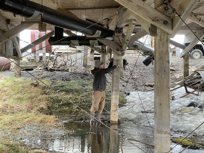
The foundations of all residential units in the village were visually assessed for signs of failure due to permafrost degradation. Roughly 30 percent of the pilings supporting homes are founded in wedge ice, where thawing in many cases has led to settlement approaching two meters, leaving about only one meter of pile embedment (Figure 5). Homes without foundations on a gravel pad were the most affected by thermokarst. We also observed that as developed areas aged, the area and depth of ice-wedge thermokarst increased. By comparing the built-up areas to the undisturbed areas north of the village located within the same terrain units, it is clear that the cumulative impact of infrastructure and climate change on thawing is considerably greater than the impact of a changing climate alone.
Community Member Observations of Permafrost Degradation
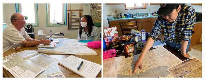
All community residents we interviewed have observed an increase in landscape changes in and around the village in recent years (Figure 6). In terms of permafrost thaw, the ground is commonly described as falling or sinking where it used to be flat, destabilizing buildings, exposing buried waste, and opening cracks in the tundra that have required new and longer routes to reach traditional hunting areas. Houses that were once close to the ground surface now appear to be on stilts due to permafrost thaw subsidence. Several community members noted that subsidence and ponding are more evident in areas with infrastructure compared with undisturbed areas outside of town, and that thermokarst is worse in areas where snow is piled in the winter. There was no consensus on when these changes first became apparent, but many observed that the speed of change has accelerated over the past few years. Frequent breaks in buried water and sewer lines are thought to contribute to this acceleration. They described how these changes are impacting life, health, and safety in the community—including risks to housing, roads and trails, food security, and the subsistence cycle.
Interdisciplinary Research Informing Community-Based Decisions
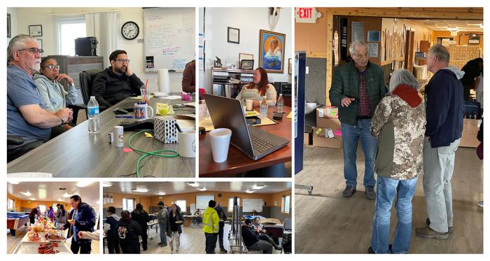
During our trip to Point Lay (Kali) and Utqiaġvik, we made a concerted effort to share our preliminary observations and findings with local and regional administrative officials and residents (Figure 7). We met with representatives of the North Slope Borough (NSB) Mayor's Office; the NSB departments of Planning and Community Services, Public Works, and Capital Improvement Program Management; the Inupiat Community of the Arctic Slope (ICAS) Tribal Government; UMIAQ Design; and the Native Village of Point Lay Tribal Council. On our final day in the village, we hosted a community barbecue that featured oral and poster presentations discussing our preliminary observations. Based on the positive engagement and knowledge-sharing that took place during the trip, our team was invited to participate in a charrette—a meeting in which all stakeholders in a project attempt to resolve conflicts and map solutions—that was hosted by UMIAQ Design in mid-July and attended by community representatives and NSB personnel. Our key recommendations during the charrette included: (1) engineering solutions to permafrost-related problems exist, but they must be applied soon; (2) filling troughs and depressions with fine-grain soil can help protect ice wedges against further degradation and thermokarst; (3) when building new construction, remove the upper portion of the ice wedges and replace it with thaw-stable soils; (4) piling embedment should be at least six meters, but deeper when founded in ice wedges; (5) when possible, place pilings in mounds between ice wedges; (6) ensure adequate drainage to minimize ponding; and (7) implement an active maintenance program that includes snow removal from areas at greatest risk from ponding and thermokarst.
Convergence Research Enhancing Permafrost Science and Engineering
Our permafrost studies in Point Lay were enhanced through convergence research, which is defined as "the integration of engineering, physical sciences, computation, and life sciences—with profound benefits for medicine and health, energy, and environment" (Convergence: The Future of Health 2016). NSF highlights two primary characteristics of convergence research: (1) being driven by a specific and compelling problem that arises from deep scientific questions or pressing societal needs, and (2) showing deep integration across disciplines that brings together intellectually diverse researchers to develop effective ways of communicating across disciplines. Our multi-disciplinary team of physical scientists, social scientists, and engineers converged in Point Lay to learn from one another and to share in discipline-centric ideas and observations that allowed for a more robust transfer of knowledge to the community, regional governance bodies, and engineers coping with the combined effects of thawing permafrost, infrastructure, and climate change.
Funding Sources
This research has been funded by three grants from the National Science Foundation: Navigating the New Arctic—Landscape Evolution and Adapting to Change in Ice-Rich Permafrost Systems (1928237), Arctic Natural Sciences—The Transition Zone of Upper Permafrost: The Frontline for Permafrost Changes across Climate and Landscape Gradients (1820883), and Arctic Systems Sciences—Causes and Consequences of Catastrophic Thermokarst Lake Drainage in an Evolving Arctic System (1806213). Additional support was provided by the US Army Corps of Engineers Cold Regions Research and Engineering Laboratory (CRREL) through a contract with Northern Social-Environmental Research.
References
Convergence: The Future of Health. June 2016, Cambridge, Massachusetts. Available at: http://www.convergencerevolution.net/s/Convergence-The-Future-of-Health….
Denali Commission. 2019. Statewide threat Assessment: Identification of Threats from Erosion, Flooding, and Thawing Permafrost in Remote Alaska Communities. Report #INE 19.03. p. 99. Available at https://www.denali.gov/wp-content/uploads/2019/11/Statewide-Threat-Asse….
Wolken, G. J., A. K. Liljedahl, M. Brubaker, J. A. Coe, G. Fiske, H. Hvidtfeldt Christiansen, M. Jacquemart, B. M. Jones, A. Kääb, F. Løvholt, S. Natali, A. C. A. Rudy, and D. Streletskiy. 2021: Glacier and Permafrost Hazards. Arctic Report Card 2021. T. A. Moon, M. L. Druckenmiller, R. L. Thoman, Eds., https://doi.org/10.25923/v40r-0956.
About the Authors
 Benjamin M. Jones is a Research Professor in the Institute of Northern Engineering at the University of Alaska Fairbanks. His research focuses on Arctic and sub-Arctic systems and combines the use of GIS and remote sensing techniques with field observations and laboratory analyses to better understand the causes and consequences of landscape change, processes, and feedbacks in northern high-latitude environments across a multitude of spatial and temporal scales.
 Jana L. Peirce is a Project Coordinator and Communications Specialist at the Alaska Geobotany Center, Institute of Arctic Biology, at the University of Alaska Fairbanks. She works closely with the Native Village of Point Lay Tribal Office, local steering committee, and Kali School to plan community and educational outreach activities and opportunities for local participation in NSF-funded research examining permafrost degradation and adaptation in Point Lay. Jana also assists with data collection, analysis, and reporting.
 Mikhail Kanevskiy is a Research Assistant Professor in the Institute of Northern Engineering at the University of Alaska Fairbanks. He studies structure and properties of permafrost, ground-ice content, and distribution in the upper permafrost, and permafrost-related hazards. Mikhail has performed fieldwork in various parts of Alaska.
 Tracie Curry, Northern Social-Environmental Research—is an interdisciplinary practitioner with broad expertise in sustainability science, qualitative and mixed methods research, and community engagement. As owner and principal researcher of Northern Social-Environmental Research (NSER), Tracie leverages her extensive experience performing research and stakeholder engagement activities on behalf of communities, organizations, and research teams. She is also an Affiliate Assistant Faculty member of the International Arctic Research Center at the University of Alaska Fairbanks.
 Bill A. Tracey, Sr. is a longtime resident of the community of Point Lay, Alaska. Bill is a local historian, community planner and developer, and member of the local steering committee for a permafrost research project in Point Lay. Bill was instrumental with the site preparation, relocation, and the development for the past two village locations of the Point Lay townsite.
 Billy Connor is the Director of the Arctic Infrastructure Development Center under the Institute of Northern Engineering at the University of Alaska Fairbanks. His focus is on the performance of infrastructure in the Arctic, including the interaction of the infrastructure with the permafrost in a changing climate. He recently co-authored the report, Roads and Airfields Constructed on Permafrost, A Synthesis of Practice.
 Yuri Shur is a Professor of Civil Engineering at the College of Engineering and Mines at the University of Alaska Fairbanks. He specializes in engineering of foundations in permafrost, the impact of pavement on permafrost, seasonal frost and its impact on structures, mass transfer, properties of frozen and thawing ground, thermokarst, shore erosion, heat transfer, thermal modeling, and thermal design.
 Peppi Bolz is a geological and cold regions engineer in Fairbanks, Alaska, focused on the inter-relationship between permafrost and infrastructure. She has worked on numerous cold regions engineering projects throughout Alaska and was part of the University of Alaska Fairbanks Geophysical Institute for this research.

