By: Matthew Druckenmiller, National Snow and Ice Data Center; and Olivia Lee, Hajo Eicken, and Rick Thoman, International Arctic Research Center, University of Alaska Fairbanks
The Sea Ice for Walrus Outlook (SIWO), now in its tenth year, provides Alaska Native subsistence hunters and Bering Strait coastal communities with weekly reports on spring sea ice and weather conditions. In turn, SIWO community observers share weekly observations about sea ice, marine hazards, wildlife sightings, and hunting activity. Together, this platform for sharing, which is also supported by an active Facebook page, provides a framework for tracking sea ice conditions and their implications at both the local and regional scales. Weekly SIWO reports integrate scientific and Indigenous knowledge into a resource that is valuable to both local communities and scientists.
The unprecedented low winter sea ice in the Bering Sea during 2018 (McFarland et al. 2018) quickly raised broad concerns regarding whether the Bering Sea had entered a new regime and the potential impacts on the ecosystem, Indigenous communities, and fisheries. The role of a program like SIWO in sharing information is becoming increasingly valuable in assisting to understand how rapid environmental change and variability are experienced within communities as they pursue the abundant walrus, whales, seals, fish, crabs, and other marine life from the Bering Sea. The local community reports also provide valuable information on the behavior of marine mammals and other wildlife in relation to changing sea ice habitat – a critical observing contribution as there is currently no surveying effort in spring 2019 for marine mammals in the Bering Strait region. A video of walrus just offshore of Gambell, Alaska, created by SIWO Observer Clarence Irrigoo, Jr., can be viewed here.
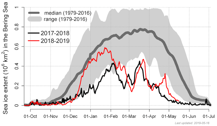
As we entered 2019, few expected that the Bering Sea would see another winter like that of last year as described in the 2018 March SIWO archive. Yet, this assessment did not hold for long. After a record low ice extent in November, a sustained colder weather pattern was established during December and early January and this allowed for significant ice extent growth. However, even during this time there were reports that nearshore ice was not as thick as expected, given the temperatures. Between mid-January through early March, the Bering Sea experienced an astonishing decline in sea ice coverage (see Figure 1), and by late February had dropped below the record low ice levels of 2018. At this time of year, the Bering Sea ice cover is typically still advancing and building towards maximum coverage, which usually occurs in mid to late March. The winter of 2019, however, was marked by the same large fluctuations in ice coverage and storm activity that defined 2018, though the timing differed between the two years.
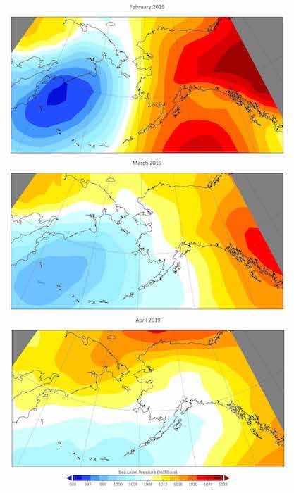
Given recent and overall warming in the western Arctic, sea ice in 2019 was thinner than the ice of past decades, which means that today's thin sea ice is more susceptible to regional-scale shifts in its distribution by winds. Large ice floes and shorefast ice are also more likely to break up in response to wave action. During February, there was pronounced low pressure over the central and western Bering Sea and high pressure over the North American continent (see Figure 2), which brought warm southern air into the region, slowing ice growth and pushing sea ice far to the north. All total, more than a dozen distinct storms and weather fronts impacted the Bering Strait region between late January and early March. The month of February saw the most ice pushed northward to reveal vast stretches of open water. Between the last week in February through to the second week in March, the Bering Strait region was almost entirely ice free, as evident by the photos shown below.
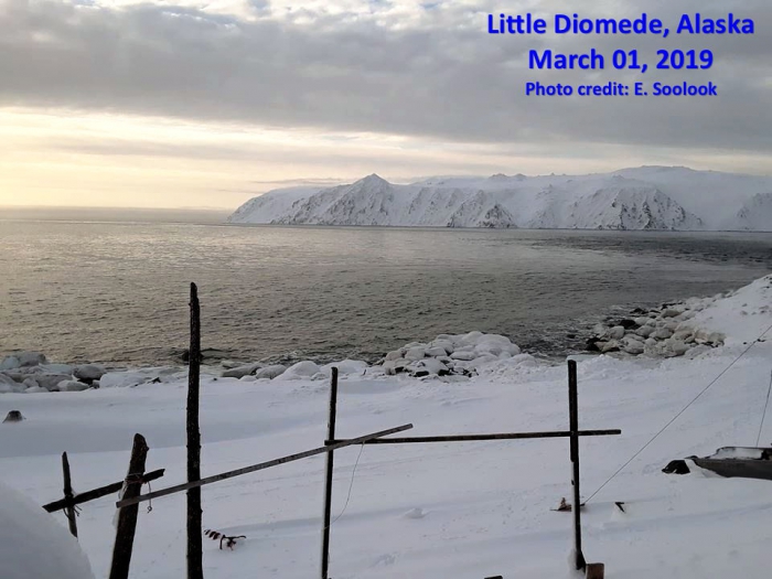
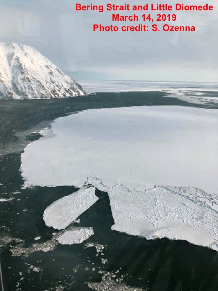
Editor's note: Photos accessed from Alaska Climatologist Rick Thoman's Twitter feed.
At Wales, for example, the community lost their shorefast ice on or around 4 March. Robert Tokeinna Jr. posted his observation and a series of photos to the Local Environmental Observers (LEO) Network. (Editor's note: See in this issue of Witness, The LEO Network, Addressing Climate Change One Event at a Time). In his 5 March posting (Tokeinna and Lee 2019), Robert observed that:
"Usually, Wales has shore fast ice until June or so in more recent years though it has been shorter; but for some reason and warming of the ocean, we lost all the shore fast ice. I rode up the beach to find all the ice not intact, but crushed and broken up. This is a very unusual event for Wales as many of our hunters rely on great ice conditions for whale and other sea mammal catch for food."
A photo from Robert is shown below, alongside a historical photo from the Wales Sea Ice Dictionary (Weyapuk and Krupnik 2012), which shows June shorefast ice at Wales. Five to ten years ago, shorefast ice thickness at Wales in early March was measured at around three feet, growing to four feet or more by May, before spring shorefast ice break-up. Current conditions in the Bering Sea guarantee that such past stable, thick shorefast ice conditions into late May or early June will not be observed this year, and there is no indication that current atmosphere-ocean warming trends will reverse to allow the buildup of thicker ice over coming years.
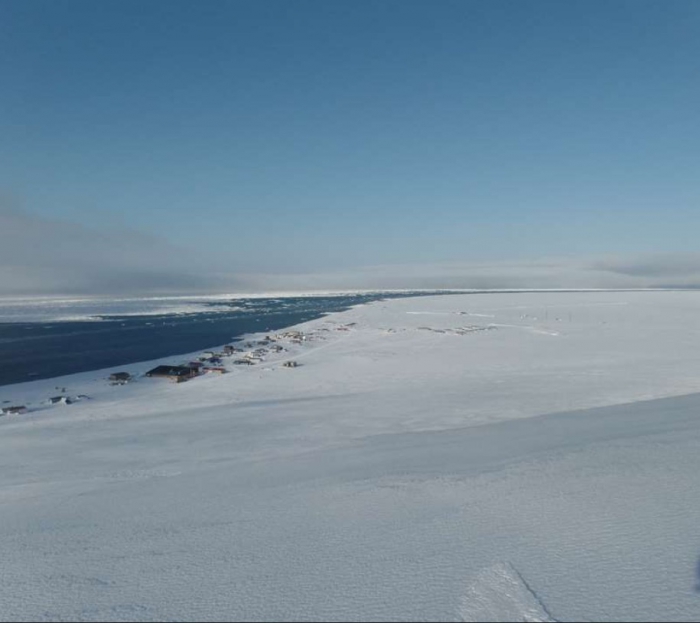
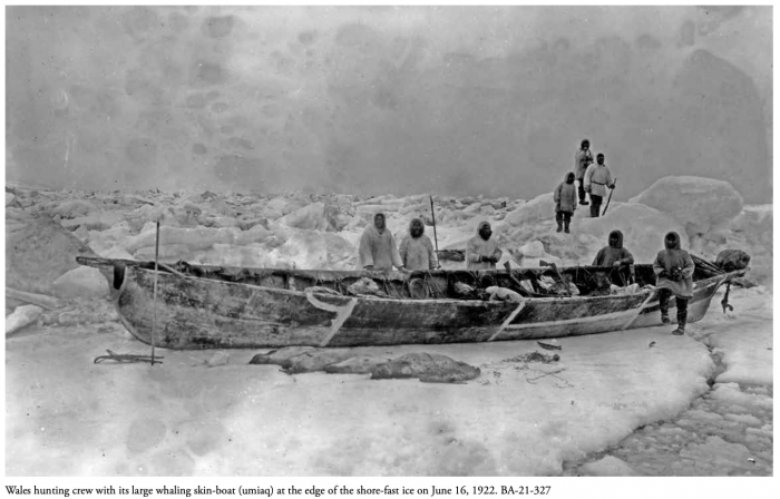
Editor's note: The 1922 photo is sourced from the Wales Sea Ice Dictionary.
Kotzebue Sound and much of the southeastern Chukchi Sea north to Kivalina were also almost entirely ice free during the 2019 mid-winter period (approx. 24 Feb. to mid-March), which emphasizes that the changes observed during such extreme winters are not confined to the Bering Sea but are reaching further north. By the first week in March, sea ice extent in the Bering Sea was the lowest in the satellite record (1979-2019).
Sea surface temperatures throughout the winter were very warm (up to 3ºC or 5ºF above normal), which impeded sea ice formation and thickening throughout winter. Figure 3 shows that on 5 March, the day of the lowest ice extent in March of this year, there was a band of extremely warm water extending from the western Bering Sea into Bristol Bay, as well as "hotspots" in the northern Bering Sea and at the entrance to Norton Sound. In past years, growth and movement of ice into such areas of warm water would have consumed much of the heat.
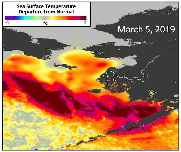
Ice coverage increased substantially throughout the middle of March, more so as a result of shifting winds rather than new ice growth. By the third week in March, ice extent in the Bering Sea rose slightly above last winter's level. With much thinner ice, the region continued to see substantial variability in ice extent, as the ice readily responded to shifts in wind and air temperature. Also, the thinner and weakly anchored shorefast ice near communities was also highly vulnerable to pack ice being blown in and breaking it up, as well as offshore winds causing ice to detach from the coast.
At Port Clarence and Brevig Mission, SIWO Observer Marcus Barr observed on 12 April that:
"Strong north winds and strong current broke up ice faster. One day of south wind brought shorefast ice back in but went back out after another strong northerly wind. More variety of sea birds started to show up. More beluga was spotted but not within the last few days. None of the locals caught walrus yet but still get bearded seals."
During April, higher pressure over the Chukchi Sea relative to lower pressure over southwest Alaska and the southern Bering Sea (see Figure 2) brought north winds that were responsible for a late-season partial recovery in ice coverage. During this time, SIWO observers reported on conditions that allowed for successful hunting.
From Nome, Boogles Johnson reported on 19 April that:
"There currently is pack ice south of Cape Nome which is good ice. We found Oogruk "bearded seal" and were successful and are now done Oogruk hunting for this season. The walrus have been to the west of Nome by Sledge Island making their migration north with their babies. The season is approx. 1 month early from previous years but the advantage is that we have snow for natural refrigeration and cold temps to preserve the catch. It has been a successful season for my crew I'm with this year and I hope all hunters are able to bring home catch to their families and community."
From the village of Gambell, Clarence Irrigoo, Jr. noted on 18 April that:
"The whalers landed a 57-foot whale on the 13 April 19. Lots of ice still around and the weather is very windy."
By early May, the Bering Sea was mostly ice-free, more than one month ahead of schedule (see Figure 1), with the main ice edge well into the Chukchi Sea (See: Sea Ice Extent, 29 May 2019. On the pan-Arctic scale, sea-ice extent in mid-May is well below normal. (See: Arctic Sea Ice Extent, February—May 2019. Warm water from the Bering Sea, due in large part to the conditions of winter 2019, is expected to contribute to another low summer sea-ice cover in the Arctic Ocean.
The Arctic summer sea-ice minimum continues to serve as one of the most highly visible indicators of a changing Arctic. However, some of the most transformative environmental changes and the most warming (e.g., Walsh et al. 2018) are taking place during the Arctic winter. Continued information sharing within SIWO may help to further elucidate what information local communities find useful as they respond by adapting their hunting and other food harvesting strategies in the changing Bering Sea.
References
McFarland, H.R., H. Eicken, R. Thoman, Z. Labe, M. Druckenmiller, and G. Sheffield. 2018. Bering Strait: An overview of winter 2018 sea ice conditions. International Arctic Research Center, University of Alaska, Fairbanks.
Tokeinna, R. and O. Lee. 2019. Wales Loses Shore Fast Ice. LEO Network (leonetwork.org). Posted 5 March 2019; Accessed 19 May 2019.
Walsh, J.E., R.l. Thoman, U.S. Bhatt, P.A. Bienikk, et al. 2018. The High Latitude Marine Heat Wave of 2016 and its Impact on Alaska (Chapter 8). In: Explaining Extreme Events of 2016: From a Climate Perspective. Special Supplement to the Bulletin of the American Meteorological Society, Vol. 99, No. 1, January 2018.
Weyapuk, Jr. W., and I. Krupnik, compilers. H. Anungazuk, I. Krupnik, and M.L. Druckenmiller, editors/contributors. 2012. Kifikmi Sigum Qanuq Ilitaavut – Wales Iñupiaq Sea-Ice Dictionary. Arctic Studies Center, Smithsonian Institution, Washington, D.C., 112 p.
- This article was adapted from an original contribution to the Sea Ice for Walrus Outlook (SIWO) in March 2019 as a summary of the "State of the Ice at Season's Start" (https://www.arcus.org/siwo/2019-03-22).
About the Authors
 Matthew Druckenmiller is a research scientist at the National Snow and Ice Data Center and a member of the Study of Environmental Arctic Change (SEARCH) Sea Ice Action Team. His research is focused on how Arctic Indigenous communities use and rely on changing environments and communicating the societal implications of Arctic sea ice loss.
 Olivia Lee is an Assistant Professor in the International Arctic Research Center (IARC) at the University of Alaska Fairbanks. Her research focuses on the integration of community observations and remote sensing imagery of sea ice to assess walrus and ice seal habitat in northern Alaska. She also works on participatory scenarios projects that aim to broaden our understanding of the socio-economic and biophysical drivers affecting the future of the Arctic.
 Hajo Eicken is Professor of Geophysics and Director of the International Arctic Research Center at the University of Alaska Fairbanks. His research focuses on sea ice geophysics, Arctic coastal processes, and their importance for human activities and ecosystems. In Alaska he has helped lead efforts to advance collaborative research with Indigenous knowledge holders and to enhance use of scientific data by Arctic communities and government agencies. This work draws on a number of different approaches, including participatory scenarios and community-based monitoring. For more than a decade, he has worked with colleagues to establish a sea-ice observatory at Utqiaġvik/Pt. Barrow. Other collaborative efforts include his involvement in helping launch the Arctic Sea Ice Outlook and Sea Ice Prediction Network, his co-leadership of the Arctic Observing Summit, and service as Chair of a National Academies Standing Committee on Offshore Science and Assessment.
 Rick Thoman works as a climate specialist with the Alaska Center for Climate Assessment and Policy at the University of Alaska Fairbanks where he focuses on providing Alaskans with timely and relevant information. He has worked in Alaska weather and climate for more than 35 years, including more than 30 years with the National Weather Service in Nome and Fairbanks.
