An interdisciplinary team of researchers has applied a systems science approach to investigate how dramatic changes in permafrost features influence the structure and function of the arctic landscape. This study, led by W. B. Bowden of the Rubenstein School of Environment and Natural Resources at the University of Vermont, focuses on the composition of vegetation, the distribution and processing of soil nutrients, and exports of sediments and nutrients to stream and lake ecosystems to help understand how thawing permafrost will change the arctic landscape and other implications.
Changes in Permafrost
A warming arctic climate may have significant impacts on systems in the arctic region, including thawing of a substantial portion of the permafrost in coming decades. Permafrost is defined by the primary condition of soil temperature that remains below 0˚ C (32˚ F) for two years or longer. Most permafrost in the Arctic contains some amount of frozen water. In areas where the content of ground ice is particularly high, the risks of permafrost thaw are greater. The threats of thermal erosion to civil infrastructure have been recognized for some time. More recently attention has turned to the impacts that thermal erosion might have on undeveloped arctic ecosystems.
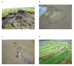
One of the most obvious effects is the formation of thermo-erosional features (see Figure 1), an extreme case of thermokarst formation. The term "thermokarst" generally refers to the uneven ground that occurs when permafrost—especially ice-rich permafrost—thaws and the ground surface subsides as the soil structure weakens and becomes plastic. In extreme cases, the soil becomes so fluid and weakened that it fails entirely, creating a variety of features that resemble landslides as seen in non-arctic areas. These thermo-erosional features appear to have become more common in recent decades in upland areas like the foothills of the Brooks Range in Alaska (Gooseff et al. 2009). This suggests that the rate of thermo-erosional processes has increased at the same time as significant warming of arctic air and soil has been observed. These thermo-erosional features may be a warning of future impacts of arctic warming (Bowden 2010).
Thermo-erosion of permafrost is important because it sets in motion a series of changes to the arctic landscape that include, but are not limited to, fundamental changes in hydrology, patterns of snow accumulation, soil microbial processing, vegetation communities, and habitats and resources available to wildlife. All of these and more will have direct and indirect impacts on human communities.

Thermokarst Project Framework
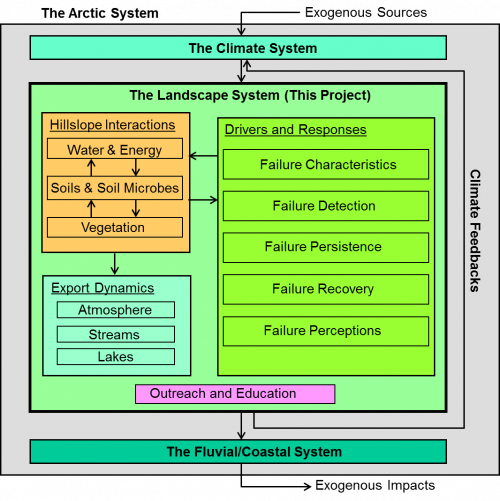
The Arctic System Science/Thermokarst project, supported by NSF's Arctic System Science Program (ARCSS), was established in 2008 to use a systems approach to investigate how the structure and function of upland landscapes will change as permafrost thaws (see Figure 2). The project focused on the dynamics of permafrost degradation and thermo-erosion in upland regions because a large portion of the Arctic is in upland areas, because less is known about this region compared to coastal plains and peat plateaus, and because thermo-erosional processes might differ in upland regions compared to these other areas due to fundamental differences in topography, precipitation regimes, and runoff characteristics.
The ARCSS/Thermokarst project was designed to address a set of interrelated questions that included:
- What physical factors predispose hill slopes to fail when permafrost thaws?
- How do soil and water chemical characteristics change when thermo-erosional features form?
- How do the fluxes of carbon, nutrients, and sediment change?
- What are the short-term and long-term trajectories of carbon and nutrient accumulation, including vegetation regrowth?
- What are the implications of past and future landscape change?
This research was conducted in the vicinity of NSF's Toolik Field Station in northern Alaska (N68˚ 38', W149˚ 36'), which is approximately 255 km north of the Arctic Circle and at an average elevation of 720 m above sea level in the foothills of the Brooks Range. The mean annual temperature ranges from -6 to -11˚C, with summer highs of 10 to 18˚C and winter lows of -30 to -40˚C. Mean annual precipitation ranges from 250 to 407 mm, with 30 to 40% falling as snow between September and May. The dominant vegetation community is tussock tundra, defined by the tussock-forming grass Eriophorum vaginatum intermixed with shrubs, primarily dwarf birch (Betula nana) and several species of willows (Salix spp.). Vegetation and soils in the study area have developed in response to interactions among the glacial legacy of the area, topography, and climate.
Study Findings
The team found that the common thermo-erosional features in this region are thaw slumps, thermo-erosional gullies, and active layer detachment slides (see Figure 1). These features significantly redistribute and reduce soil carbon and nutrients. Sediments and nutrients are exported from thermo-erosional features and may impact streams and lakes. In general, productivity was greater in streams and lakes influenced by thermokarst inputs; i.e., nutrient stimulation outweighed sediment interference. The effects seem to be transitory on the time scale over which these thermo-erosional features form, stabilize, and are re-vegetated—perhaps on the order of several decades.
The team found that field measurements of the rates at which carbon and nutrients accumulate after these thermo-erosional features stabilize led to estimates that were much faster than their estimates based on model predictions. This finding suggests that alternative sources of carbon and nutrients must be available.
For the research team, one of the most intriguing results from this work is the realization of how numerous thermo-erosional features have become. In one area the team studied intensively, there were over 7,000 identifiable thermo-erosional features in an area of about 1,681 km2, or more than four features per square kilometer. Given the local impacts identified by studying individual thermo-erosional features, the team concludes that these features are likely to be important agents of change in the structure and function of the arctic landscape and may become even more important as the permafrost continues to thaw.
For further information about the ARCSS/Thermokarst project, contact W. B. Bowden (breck.bowden [at] uvm.edu).
References
Bowden, W. B. 2010. Climate Change in the Arctic: Permafrost, Thermokarst, and Why They Matter to the Non-Arctic World. 2010. Geography Compass 4(10): 1553–1566. DOI: 10.1111/j.1749-8198.2010.00390.x. Article first published online 3 October 2010.
Gooseff, M. N., A. Balser, W. B. Bowden, and J. B. Jones. 2009. Effects of Hillslope Thermokarst in Northern Alaska. Eos 90(4): 29-36. (27 January 2009.)

