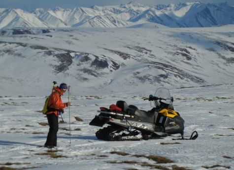
During mid-April 2012 an interagency team completed a 13-day campaign as the first phase of an innovative field project, entitled SnowSTAR 2012, to measure the snow cover of the North Slope of Alaska. The 16-member team, funded in part by NSF’s Arctic Sciences Division, included scientists from the U.S. Army Cold Region Research and Engineering Laboratory (CRREL), the University of Alaska, Colorado State University, the U.S. Forest Service, the National Snow and Ice Data Center, and Ultimate Thule Lodge. Working near Toolik Lake, just north of the Brooks Range, the team measured the snow characteristics using a variety of techniques including snow pits, GPS-enabled snow depth probes, snow cores for snow water equivalent (SWE); and also indirectly measured the snow using both airborne and ground-based LiDAR (Light Detection And Ranging) equipment. The goal of the project is to develop a more effective way of measuring snow depth in variable conditions and over large areas.
Snow cover in northern Alaska lasts eight months of the year. Understanding the characteristics of the snow cover is important for several reasons. First, it is a significant source of the fresh water in the region—an estimated 50-80% of the run-off in the rivers in this part of Alaska comes from snowmelt alone. Second, snow is an effective insulator. Without the snow permafrost in this region might be thicker and colder, the summer thawing active layer thinner, and the plant life less verdant. Third, the snow has a high albedo, reflecting about 85% of incoming solar energy. The fine balance between the insulation effect and the solar reflecting effect of snow plays a critical role in the climate of the Arctic with implications for the entire planet. Accurate snow depth measurements also provide important information for land use management. For example, it can inform the State of Alaska and the U.S. Government, which manage thousands of square kilometers of land on the north slope of Alaska, in deciding where and when to allow oil, gas, and mining companies to transit over the tundra.
Snow depth across the North Slope of Alaska can be extremely variable. Wind constantly moves the snow creating drifts and scour zones. In the space of 100 meters, snow depths can range from 10 to 500 centimeters (cm). Previous methods of measuring snow depth have yielded some successes, but efficient operational level methods that work for all types of snow have not emerged. The problem has been especially acute for snow that tends to be thin (
The ground campaign was designed to characterize snow properties so that these measurements could be compared to results collected using ground-based and airborne LiDAR.
The ground-based campaign therefore focused on accomplishing three tasks:
- Setting up a precise GPS control network, including high-order base stations, to allow the aircraft to navigate with 10 cm positioning precision;
- Operating ground-based LiDAR to produce small and specific targets where the snow surface topography was measured to centimeter accuracy; and
- Measuring snow depth and snow water equivalent (SWE) along the planned flight path—with minimum snow disturbance—before the aircraft flies.
One of the unique aspects of the ground snow measurements involved digging snow pits. These pits are dug with vertical walls and square corners; they allow researchers to look at the snow layers, which provide a stratigraphic record of the winter’s wind, snowfall, and thaw events. The arctic snow pack has a high percentage of depth hoar frost and frequent surface hoar frost formation due to severe cold and strong temperature gradients. The snow surface can be -30°C while the base of the snow will be -10°C, driving heat and moisture from the warm base to the cold surface of the snow. Due to this metamorphic process, very little of the snow layer texture is due to the nature of the initial snowfall.
Measuring snow depth also included use of the "MagnaProbe," a device invented by CRREL, which measures snow depth and a GPS position at the same time (see http://www.snowhydro.com).

LiDAR Campaign
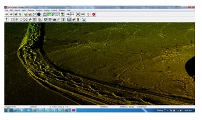
After eight days of preparation work the aircraft arrived to do airborne LiDAR while the ground crew collected ground-based LiDAR data for comparison. Scanning LiDAR equipment uses a laser rangefinder to measure surfaces. LiDAR works by hitting the surface with laser pulses and can only scan along a line of sight. For ground-based LiDAR anything out of the line of site - such as the backside of small hills within the scan area - is missed in the scans. To fill these gaps the team established multiple LiDAR station positions around an area of interest, making scans first of one side of hills, then of the other, and overlaying the scans to build a full surface. In order to overlay the scans accurately targets were set around the site and located by the scanner for each position. Data collected at each site was then rotated and shifted until the targets lined up. This allowed the team to very precisely tie the scans collected from different viewpoints together into a single surface map.

Ground-based scanning LiDAR collects 11,000 points in less than half a second averaging between 20 and 30 million points at each site. This enables the ground-based LiDAR team to produce 3D surface maps with very high resolution (a few hundred points per square meter) and very high accuracy (approximately ±0.5 cm vertical resolution).
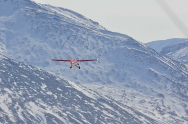
Airborne LiDAR is mounted on an aircraft, pointing down. It runs continuously as the plane flies and collects 10-100 times more data than ground-based LiDAR. However, airborne LiDAR has lower accuracy than the ground-based system (approximately 10 cm vertical resolution).
To calculate the snow depth the team will return after snowmelt and collect LiDAR data at the same locations to create a second surface. With the use of Differential Global Positioning Systems (DGPS), a precise co-registration of the two maps is possible. Subtracting the ground surface from the snow surface will yield a map of the snow depth with high accuracy. Using the snow cores, team members will develop a simple regression equation to convert snow depths into snow water equivalents and produce maps of snow pack across the study region.
Results

SnowSTAR 2012 succeeded in collecting a very large dataset of snow measurements over the same areas using a number of different techniques. The team took more than 100,000 ground-based snow depths spread across a 200 kilometer swath of northern Alaska, dug 20 detailed snow pits, obtained 286 snow cores that were weighed for snow water equivalent (average density was 283 kg/m3), produced 19 ground-based LiDAR maps, and collected more than one hundred square kilometers of airborne LiDAR mapping along a swath about 200 meters wide.
The ground data are currently being uploaded into ACADIS. The airborne and ground LiDAR will require more processing before they can be archived.
For further information about the SnowSTAR 2012 project, please see the five dispatches produced during the field campaign and posted on the Scientific American website or contact Matthew Sturm (Matthew.Sturm [at] erdc.dren.mil).
