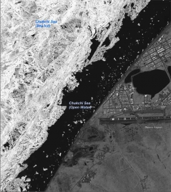
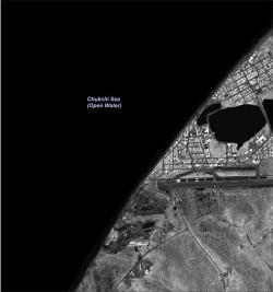
In July 2009, the Polar Research Board (PRB) issued a report, Scientific Value of Arctic Sea Ice Imagery Derived Products, recommending the release of a suite of arctic sea ice images collected by U.S. government intelligence sources. The PRB report committee determined that the images could help scientists examine the effects of climate change and the impacts of diminishing sea ice and lead to significant improvements in the development of climate models. Shortly after the report was released, the U.S. Geological Survey's (USGS) Civil Applications Program launched a website to disseminate a selection of these sea ice images.
| Location | Year Collected and Number of Images Available |
|---|---|
| Barrow (71°N, 156°E) | 2005–2006: 18 images 2007–2008: 8 images |
| Beaufort Sea (73°N, 150°W) | 1999: 12 images 2000: 33 images 2001: 27 images 2002–2005: 19 images 2006–2008: 19 images |
| Chukchi Sea (70°N, 170°E) | 2005–2006: 20 images 2007–2008: 7 images |
| Canadian Arctic (85°N, 120°W) | 1999: 12 images 2000: 31 images 2001: 30 images 2002–2006: 16 images 2007–2008: 20 images |
| Canadian Fram Strait (85°N, 0°E) | 1999–2000: 28 images 2001: 46 images 2002–2006: 19 images 2007–2008: 14 images |
| East Siberian Sea (82°N, 150°E) | 2000: 32 images 2001: 32 images 2002: 23 images 2005–2007: 20 images 2008: 25 images |
The U.S. Geological Survey's Civil Applications Program recently launched a website to disseminate a selection of aerial sea ice images, which were derived from satellite imagery classified by the U.S. government. The box above shows the location, year collected, and number of sea ice images available on the site.
During the 1990s, the U.S. government's Medea program brought together scientists and members of the intelligence community to apply classified information and data to further the understanding of environmental change. Under Medea auspices, the Global Fiducials program enabled participating scientists to request collection of classified images at environmentally sensitive locations around the globe. The term "fiducials" refers to the fact that the classified images were to be kept "in trust" in classified archives, with the eventual goal of declassification and release to the broader scientific community for research purposes. In 1999, scientists requested that the intelligence community collect images of sea ice at four locations in the Arctic Basin during the summer months; two additional locations were added in 2005. Images have been collected at these sites during the summer months until the present day.
In later years of the program, images called Literal Imagery Derived Products (LIDPs) were produced from the classified data at a resolution deemed suitable for unclassified release. To date, several hundred unclassified LIDPs have been produced from the images collected at the six arctic sites and will continue to be produced from classified sources in the future.
To assist in the process of making the unclassified derived imagery more widely useful, the PRB committee reviewed the images and considered their potential uses for scientific research. The resulting report contains information on the importance of sea ice in the Arctic and illustrates possible uses of the derived images.
Projections of future arctic ice cover are hampered by poor understanding of sea ice physical processes because few observations exist at appropriate times and scales. Readily available satellite images are too coarse to capture the details, the report says. In addition, collecting ground-based data by maintaining manned-drifting stations is challenging due to rapidly changing environmental conditions and the weak platform of ice, and collecting data from observational aircraft flights is difficult and expensive.

Aerial Sea Ice Image
Committee members identified immediate priorities for dissemination: all data from 2007–2008, which would enhance the value of a broad range of intensive ground-based observations carried out during the International Polar Year, as well as all images from both the Barrow and Beaufort Sea locations. The data from Barrow will provide information that may help inform coastal communities on ecosystem shifts as they adapt to a changing climate, and the images from the Beaufort Sea depict a broad range of ice types and ages that can add to scientists' ability to monitor and forecast ice movement.

Aerial Sea Ice Image
The committee concluded that the images should be released to the public as soon as possible and outlined what information should be included in the metadata. The committee recognized the need for additional observations at the North Pole as well as dynamic image collection designed to enable scientists to track specific ice floes and to study how their features change over time; this would complement the existing system whereby images are taken at a particular point in space as various ice features pass through. The committee also noted that any corresponding radar data should be made available as well.
In response to the report recommendations, the USGS Civil Applications Program made the images and accompanying metadata publicly available on the Global Fiducials Library website at: http://gfl.usgs.gov/. The site currently contains a total of 700 LIDP images produced from imagery at the arctic sites, and USGS plans to continue to publish LIDP images online as new observations are collected.
The PRB is a unit within the National Academies and is responsible for studies related to the Arctic, Antarctic, and cold regions in general. The report is available online at: www.nap.edu/catalog/12631.html. For more information, contact study director Curtis Marshall cmarshall [at] nas.edutitle="Email cmarshall [at] nas.edu"; 202-334-3533).
