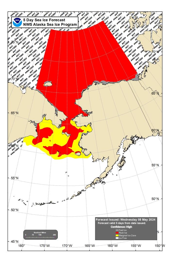
Assessment of Current Ice Conditions Relevant to Distribution and Access of Walrus
Click the name of each community below to view more frequently updated and detailed information from the National Weather Service.
Synopsis: A low pressure trough along the West Coast of Alaska will persist into this weekend. A strong low in the southern Bering Sea will move east to the Alaska Peninsula by Friday, May 10, then into the Gulf of Alaska Saturday, May 11. High pressure will build over the Bering Sea on Sunday, May 12 and persist into Monday night. Another low will move east across the Bering Sea Monday night, May 13 through Wednesday, May 15, and move over the West Coast of Alaska Wednesday night, May 15 or Thursday, May 16, with high pressure building over the Bering Sea again on Thursday, May 17.
Near St. Lawrence Island
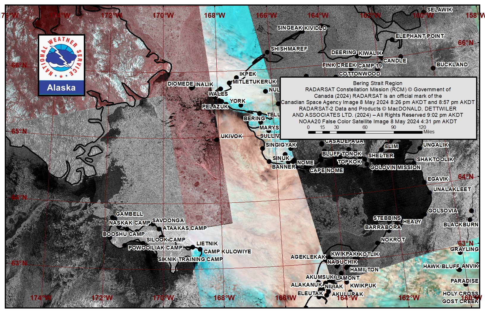
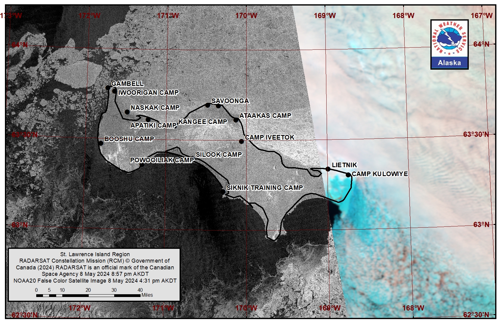
A polynya south of the island extends up to 125 miles (201 km) from the coast, with open water extending up to 38 miles (61 km) from the coast. East of Gambell and around the east side of the island is consolidated pack ice consisting of big to giant floes. West of the island is close pack ice consisting of mostly big to vast floes, with one giant floe west of Gambell.
Nome
Shorefast ice extends up to 3 miles (5 km) offshore along the Nome coastline. Beyond the shorefast ice is a polynya that extends up to 40 miles (64 km) offshore with very open pack ice. Close to very close pack ice consisting of big to vast floes then extends south beyond the polynya. East of Golovin is open water aside from the shorefast ice.
Nome port entrance webcam (via AOOS webpage): https://bering-sea.portal.aoos.org/?ls=79875242-e362-65cb-914e-fed20ff9…
Brevig Mission/Port Clarence Area
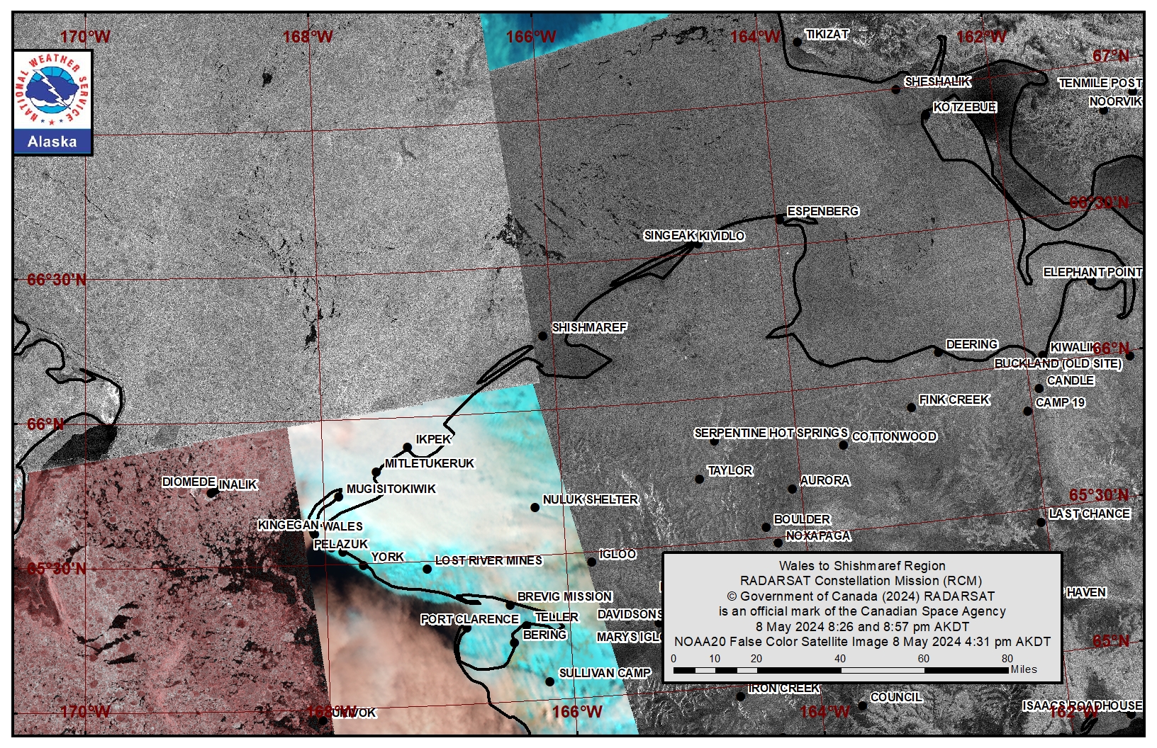
Shorefast ice remains within the area from Port Clarence to Brevig Mission. To the west of Port Clarence, the polynya extends 35 miles (56 km) to the west and is open water with brash ice to ice cakes as well as new ice beyond 18 miles (29 km). Beyond the polynya is consolidated ice consisting mainly of vast to giant floes. Between Port Clarence and Wales is an area of close pack ice consisting of medium to big floes.
Wales to Shishmaref
Consolidated ice consisting of big to giant floes extends from the Wales to Shishmaref coastline. Northeast of Shishmaref, a polynya extends south from the Point Hope to Kivalina coastline to approximately 60 miles (97 km) from Shishmaref.
Diomede
Some compact ice remains between the islands. Consolidated ice consisting of mainly vast to giant floes surrounds the island and up to 18 miles (29 km) east of the island. A polynya with open water then extends to the shorefast ice near Wales.
Forecast Discussion
Ice Forecast
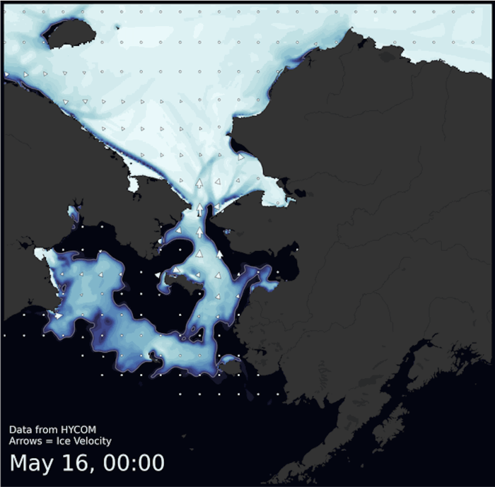
Overall, sea ice will continue to drift south through Sunday (May 12) and new sea ice will continue to form within polynyas. Sea ice movement will be more variable Monday (May 13) through Wednesday (May 15), mainly driven by a low moving southeast across the central Bering Sea. Most notable sea-ice movement during this time will be to the north briefly on Tuesday before returning to a southward drift on Wednesday and Thursday.
Wind Synopsis
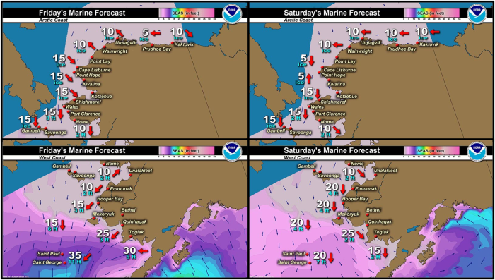
North 15 kt to 20 kt (17–22 mph) Friday, May 10 through Sunday, May 12. Winds decreasing to SW 10 kt or less (11 mph or less) Monday, May 13, then increasing to southeast 15–25 20 kt (17–23 mph) on Tuesday, May 14, become northeast 15 kt (17 mph) Wednesday, May 15, then northwest 10–15 kt (11–16 mph) on Thursday, May 16, and west 5–15 kt (5 to 17 mph) on Friday, May 17.
Temperature Trend
Temperatures in the 20s through Sunday, May 12, except in the 20s and lower 30s near Nome.
Temperatures rising into the 20s and lower 30s next week, except into the upper 20s to near 40 near Nome.
Daily Weather, Wind, and Temperature Updates
The National Weather Service provides twice-daily, text only updates on the weather, wind, and temperature conditions in specific geographical zones. An interactive weather map for access to other Alaskan zones can be found here: http://weather.gov/anchorage/ice
Higher resolution satellite images and wind maps (wind updated daily) can be viewed here: http://www.weather.gov/afg/SIWO_overview
The Alaska Ocean Observing System shares a variety of weather and sea ice related resources in their Bering Sea Portal at https://bering-sea.portal.aoos.org/.
Marine forecast for the West Coast and Arctic Coast
Remote Sensing Images
Observations and Comments
Observations of Sea Ice Development
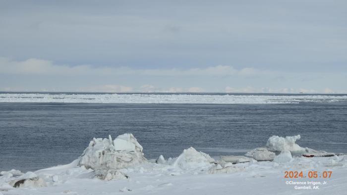
Observations from Gambell
Tuesday, 7 May 2024 – Clarence Irrigoo, Jr.
10°N, 9 mph.
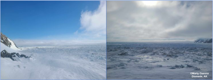
Observations from Diomede
Thursday, 9 May 2024 – Marty Eeleengayouq Ozenna
These are from the south side of the island where the ice been coming off an closing in an the weather was nice clear, had northeast winds 20–25 knots. North side of the island was closed in but can send a picture later today when the fog burns off.
Observations from Port Clarence, Brevig Mission, and Cape Douglas
Friday, 10 May 2024 – Marcus Barr
No significant changes in the shorefast ice, open water got bigger when north winds continued for awhile.

Observations from Scammon Bay
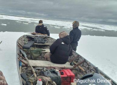
Friday, 10 May 2024 – Aguchak Dexter
Scammon Bay, Alaska. Lotta ice out there yet. 12 miles west of Scammon ice edge waiting for ice to go out Boating.
Observations from Shishmaref
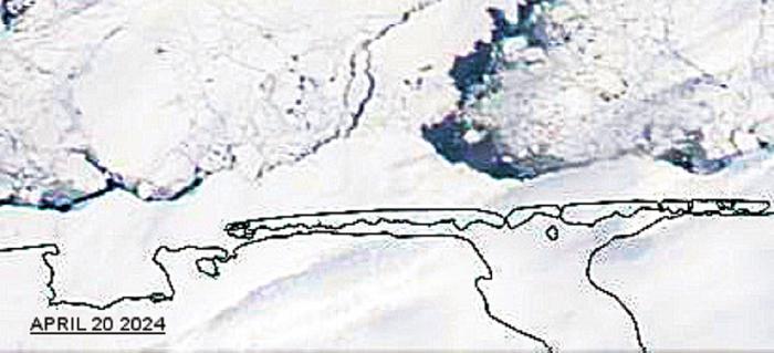
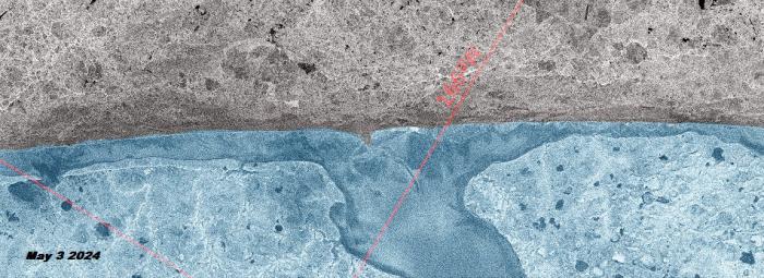
Friday, 10 May 2024 – Curtis Nayokpuk
Assume with how fast this spring (sea ice loss) is approaching and current melting temps we (SHH hunters) will be off (rotting) ice by July? Have some old sat maps to contribute to this week's SIWO for hunters to compare open leads (South winds PV April 20) and last week (WV May 5) to see what previous weeks cold North winds push back in. Been stable three mile shorefast ice as April pic all winter.
Observations from Wales
Friday, 10 May 2024 – Robert Tokeinna, Jr.
Since last week, it has been a very mild, cold week; but there are signs of spring. The coming of the Cranes have been notable the past couple days as there has been a bunch of them around. For sea ice, so far it seems to have a steady strong Shorefast Ice around Wales. It looks like there is a lot of open water with the winds predominantly Noth wind this week. Temperature have been single digits to upper 20s all week. Thawing of spring has ceased and come to a halt with these brisk Temperatures and northerly winds, but I noticed more snow bunting birds, sea gulls, and coming of the more recent Cranes which are few notable signs of spring, our Temperatures just needs to ahead of the game. No pictures as the Ice fog has been lingering the past couple of days. Once the fog breaks, I will send some photos. Happy trails to all.
Observations from Savoonga
Friday, 10 May 2024 – Aqef Waghiyi
Temp. 31F, humidity 47.7, dew point 27.5, pressure 1014.3, barometer 1014.2, wind NW at 15, cross-wind 12.6. Nobody hasn’t gone boating in a few days.
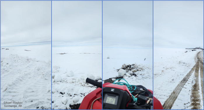
Update: A few boats came back north from whaling camp. Some got walrus and bearded seal.
Observations from Hooper Bay
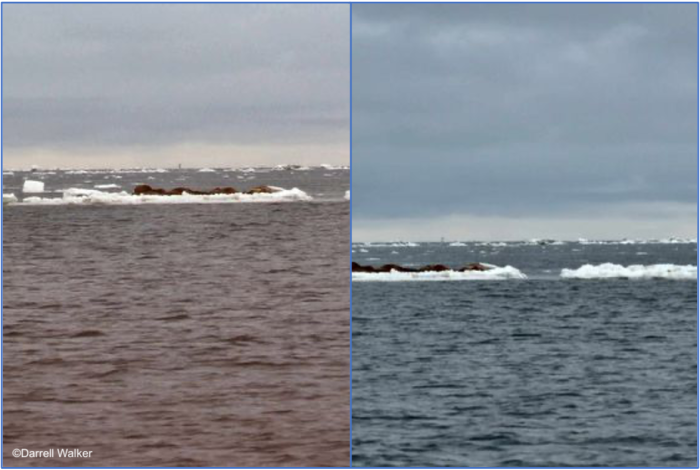
Friday, 10 May 2024 – Darrell Walker
Ice report 37 miles west of Hooper Bay.
Additional Comments Provided by Local Experts and Other Contributors
Shared by the Alaska Ocean Observing System (AOOS) for 8–16 May 2024
Visit the SIWO Facebook page @seaiceforwalrus to view this animation showing the predicted movement of ice predicted by the HYbrid Coordinate Ocean Model (HYCOM). Snapshots from the forecast show ice coverage from 0% (black) to 100% (white) and arrows show the relative speed and direction of the ice. A light boundary is drawn at 15% predicted ice cover to highlight the ice edge, but ice may be predicted to extend beyond it. Some bays, lagoons, and areas very close to shore are not covered by the model. (Image produced by the Alaska Ocean Observing System / Axiom Data Science).

